Share Safer Streets Northwest on FacebookShare Safer Streets Northwest on TwitterShare Safer Streets Northwest on LinkedinEmail Safer Streets Northwest link
Project Summary
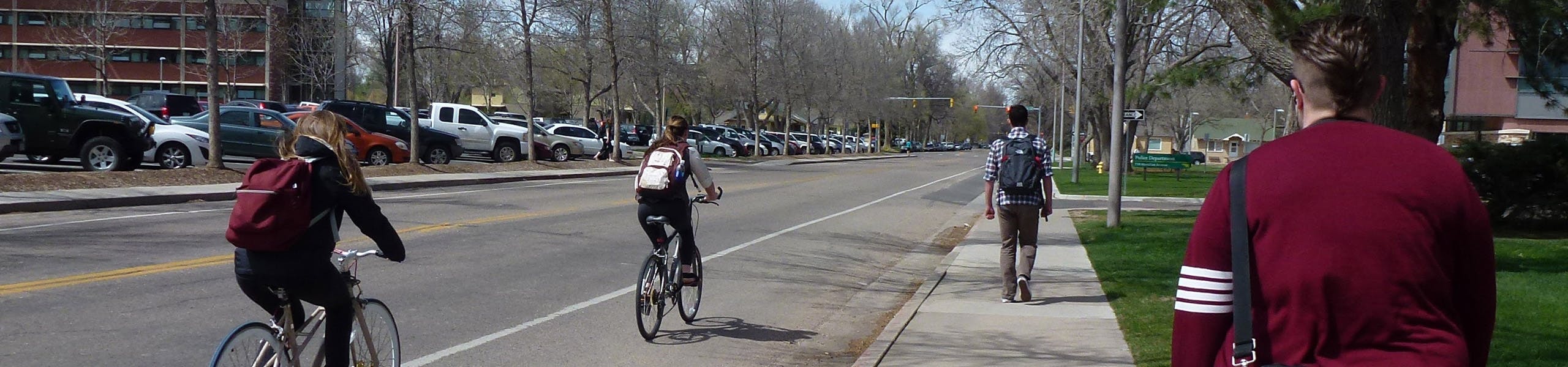
Safer Streets Northwest is a study aiming to improve travel safety and comfort along some of Fort Collins’ busiest streets.
The goal of this study: To make these streets safer, more convenient and more enjoyable for everyone—whether you’re walking, biking, rolling or driving. Funded by the federalSafe Streets and Roads for All(SS4A) program, this project supports the City of Fort Collins' broader goals around traffic safety, carbon neutrality and active transportation.
The Safer Streets Northwest study builds on the City’s Vision Zero Action Plan, Active Modes Plan and Transportation Capital Improvements, focusing on major streets in northwest Fort Collins and creating a plan for safety upgrades, street redesigns and long-term improvements. This study's outcomes will guide future investments, funding applications and projects.
Why Now?
In 2023 the City made the Vision Zero commitment to eliminate fatal and serious injury crashes by 2032. While the City has long prioritized traffic safety through enforcement and design, fatal and serious crashes still happen. This study is a proactive step toward safer streets for all.
Community Engagement
Your voice matters. We're committed to ensuring this study reflects the needs of the Fort Collins community. This study will reflect input from across Fort Collins, with a focus on reaching a diverse mix of residents.
The first two engagement phases took place from June-September 2025 and engaged over 500 community members.
In Phase 1 (June), we gathered input on which streets and segments in Northwest Fort Collins should be prioritized for safety improvements. Combining the input we received with the results of our crash analysis and review of past plans and studies, we identified three high-priority corridors: Shields Street, Taft Hill Road, and Laurel Street.
In Phase 2 (July-September), we collected targeted feedback on the three high-priority corridors.
We heard that the community is concerned about safety and connectivity, citing speeding, turning conflicts, long signal waits, and inadequate infrastructure such as narrow bike lanes and missing sidewalks.
There is a critical need to reduce speeding, provide safer crossings, and build bike lanes that offer greater protection for people riding bicycles/scooters.
The project team is now developing safety improvement recommendations to share with the community in the first quarter of 2026. Stay tuned for opportunities to provide feedback!
Project Summary
Safer Streets Northwest is a study aiming to improve travel safety and comfort along some of Fort Collins’ busiest streets.
The goal of this study: To make these streets safer, more convenient and more enjoyable for everyone—whether you’re walking, biking, rolling or driving. Funded by the federalSafe Streets and Roads for All(SS4A) program, this project supports the City of Fort Collins' broader goals around traffic safety, carbon neutrality and active transportation.
The Safer Streets Northwest study builds on the City’s Vision Zero Action Plan, Active Modes Plan and Transportation Capital Improvements, focusing on major streets in northwest Fort Collins and creating a plan for safety upgrades, street redesigns and long-term improvements. This study's outcomes will guide future investments, funding applications and projects.
Why Now?
In 2023 the City made the Vision Zero commitment to eliminate fatal and serious injury crashes by 2032. While the City has long prioritized traffic safety through enforcement and design, fatal and serious crashes still happen. This study is a proactive step toward safer streets for all.
Community Engagement
Your voice matters. We're committed to ensuring this study reflects the needs of the Fort Collins community. This study will reflect input from across Fort Collins, with a focus on reaching a diverse mix of residents.
The first two engagement phases took place from June-September 2025 and engaged over 500 community members.
In Phase 1 (June), we gathered input on which streets and segments in Northwest Fort Collins should be prioritized for safety improvements. Combining the input we received with the results of our crash analysis and review of past plans and studies, we identified three high-priority corridors: Shields Street, Taft Hill Road, and Laurel Street.
In Phase 2 (July-September), we collected targeted feedback on the three high-priority corridors.
We heard that the community is concerned about safety and connectivity, citing speeding, turning conflicts, long signal waits, and inadequate infrastructure such as narrow bike lanes and missing sidewalks.
There is a critical need to reduce speeding, provide safer crossings, and build bike lanes that offer greater protection for people riding bicycles/scooters.
The project team is now developing safety improvement recommendations to share with the community in the first quarter of 2026. Stay tuned for opportunities to provide feedback!
Share How will the proposed installation of a protected bike lane on the north side of the 100 block of West Laurel impact the few remaining on-street parking spaces in front of businesses on this block? on FacebookShare How will the proposed installation of a protected bike lane on the north side of the 100 block of West Laurel impact the few remaining on-street parking spaces in front of businesses on this block? on TwitterShare How will the proposed installation of a protected bike lane on the north side of the 100 block of West Laurel impact the few remaining on-street parking spaces in front of businesses on this block? on LinkedinEmail How will the proposed installation of a protected bike lane on the north side of the 100 block of West Laurel impact the few remaining on-street parking spaces in front of businesses on this block? link
How will the proposed installation of a protected bike lane on the north side of the 100 block of West Laurel impact the few remaining on-street parking spaces in front of businesses on this block?
CycleSense
asked
9 months ago
This is something we’re evaluating through this study! We'll have draft concept plans for Laurel Street from Shields Street to College Avenue, including the 100 block, available for public review on this webpage and at various in person public engagement events in January or February 2026.
Share Has anyone explored a City-CSU partnership to widen the existing sidewalk on CSU property along the south side of W. Laurel Street between S. College and Shields Street into a shared east-west bicycle-pedestrian path? It would make sense to focus on moving this cycling traffic from the street to CSU property since the majority of pedestiran and cycling in this corridor is related to the campus. CSU has utilized this method on campus successfully for many years to facilitate multi-modal travel and it would remove many of the vehicle related hazards for cyclists and pedestrians in this corridor. on FacebookShare Has anyone explored a City-CSU partnership to widen the existing sidewalk on CSU property along the south side of W. Laurel Street between S. College and Shields Street into a shared east-west bicycle-pedestrian path? It would make sense to focus on moving this cycling traffic from the street to CSU property since the majority of pedestiran and cycling in this corridor is related to the campus. CSU has utilized this method on campus successfully for many years to facilitate multi-modal travel and it would remove many of the vehicle related hazards for cyclists and pedestrians in this corridor. on TwitterShare Has anyone explored a City-CSU partnership to widen the existing sidewalk on CSU property along the south side of W. Laurel Street between S. College and Shields Street into a shared east-west bicycle-pedestrian path? It would make sense to focus on moving this cycling traffic from the street to CSU property since the majority of pedestiran and cycling in this corridor is related to the campus. CSU has utilized this method on campus successfully for many years to facilitate multi-modal travel and it would remove many of the vehicle related hazards for cyclists and pedestrians in this corridor. on LinkedinEmail Has anyone explored a City-CSU partnership to widen the existing sidewalk on CSU property along the south side of W. Laurel Street between S. College and Shields Street into a shared east-west bicycle-pedestrian path? It would make sense to focus on moving this cycling traffic from the street to CSU property since the majority of pedestiran and cycling in this corridor is related to the campus. CSU has utilized this method on campus successfully for many years to facilitate multi-modal travel and it would remove many of the vehicle related hazards for cyclists and pedestrians in this corridor. link
Has anyone explored a City-CSU partnership to widen the existing sidewalk on CSU property along the south side of W. Laurel Street between S. College and Shields Street into a shared east-west bicycle-pedestrian path? It would make sense to focus on moving this cycling traffic from the street to CSU property since the majority of pedestiran and cycling in this corridor is related to the campus. CSU has utilized this method on campus successfully for many years to facilitate multi-modal travel and it would remove many of the vehicle related hazards for cyclists and pedestrians in this corridor.
CycleSense
asked
9 months ago
This study is primarily focused on improvements the City can make to Laurel Street between Shields Street and College Avenue, within the roadway itself, in conjunction with an upcoming resurfacing project.
The City could explore creating a shared bicycle and pedestrian path on the south side of Laurel Street in the future, but there are some challenges with having two-way bicycle facilities on one side of the street in certain contexts. Providing one-way separated bike lanes in the direction of vehicular traffic allows for more intuitive and direct connections with the surrounding transportation network, including simpler transitions into existing bicycle lanes. It's also the most consistent with driver expectations since cyclists travel in the same direction as drivers. Providing a two-way separated bike lane or side path on one side of the street introduces a counterflow movement for cyclists. Strategies such as signal phasing, designs to slow turning drivers and signage and pavement markings are needed to manage conflicts between counterflow bicyclists and motorists at intersections, driveways and other conflict points.
Share Riding on arterial streets should never be encouraged. There are plenty of residential streets that will get you wherever you want to go in a much safer and pleasant manor. Please do not spend countless millions on remodeling more arterial streets. on FacebookShare Riding on arterial streets should never be encouraged. There are plenty of residential streets that will get you wherever you want to go in a much safer and pleasant manor. Please do not spend countless millions on remodeling more arterial streets. on TwitterShare Riding on arterial streets should never be encouraged. There are plenty of residential streets that will get you wherever you want to go in a much safer and pleasant manor. Please do not spend countless millions on remodeling more arterial streets. on LinkedinEmail Riding on arterial streets should never be encouraged. There are plenty of residential streets that will get you wherever you want to go in a much safer and pleasant manor. Please do not spend countless millions on remodeling more arterial streets. link
Riding on arterial streets should never be encouraged. There are plenty of residential streets that will get you wherever you want to go in a much safer and pleasant manor. Please do not spend countless millions on remodeling more arterial streets.
ronold
asked
12 months ago
Thank you for this feedback.
The Safer Streets Northwest Study is focused on improving safety for all modes of transportation. Arterial streets represent 91 percent of the City’s high injury network, which consists of the roads most likely to experience severe crashes based on historical crash data. There are many businesses and residences that are only accessible via arterial streets.
The City’s Active Modes Plan prioritizes improvements for walking, biking, and micromobility options like skateboards and scooters. One of the top priorities that community members expressed during engagement for the plan was increasing the available protected infrastructure, physically separated from vehicle traffic. The plan recommends constructing 64 miles of separated bike lanes and 45 miles of shared-use paths, primarily along arterial streets.


Thank you for your contribution!
Help us reach out to more people in the community
Share this with family and friends