Transfort Optimization Plan

Share Transfort Optimization Plan on Facebook Share Transfort Optimization Plan on X (formerly Twitter) Share Transfort Optimization Plan on Linkedin Email Transfort Optimization Plan link

The Transfort Optimization Plan (Phase 1) was developed through community feedback, data analysis and transit industry best practices providing the community with more frequent service on key routes and a simpler, grid-based network. The changes were designed to improve frequency, reliability and connections while operating within available resources.


Updated route maps and schedules are available at ridetransfort.com.



Planning for Phase 2 is underway with anticipated changes to Routes 14 and 18 in 2027.

The Transfort Optimization Plan (Phase 1) was developed through community feedback, data analysis and transit industry best practices providing the community with more frequent service on key routes and a simpler, grid-based network. The changes were designed to improve frequency, reliability and connections while operating within available resources.


Updated route maps and schedules are available at ridetransfort.com.


Planning for Phase 2 is underway with anticipated changes to Routes 14 and 18 in 2027.

  • August 2026: Project Updates

    Share August 2026: Project Updates on Facebook Share August 2026: Project Updates on X (formerly Twitter) Share August 2026: Project Updates on Linkedin Email August 2026: Project Updates link

    Transfort’s optimized bus network took effect Monday, Aug. 17, bringing more frequent service on key routes and a simpler, grid-based network. The changes were designed to improve frequency, reliability and connections while operating within available resources.

    Key changes included:

    • Continued fare-free service on all Transfort routes
    • More frequent service on several high-demand routes
    • All Day 15-minute service on MAX
    • Significant routing changes to Routes 2, 3, 8 and 81
    • Minor routing changes to Routes 7, 16, and Foothills Shuttle
    • Elimination of Routes 10, 11, 12, 32 and 92
    • End of Sunday service
    • Changes to Dial-A-Ride service area and service

    Transfort’s optimized bus network took effect Monday, Aug. 17, bringing more frequent service on key routes and a simpler, grid-based network. The changes were designed to improve frequency, reliability and connections while operating within available resources.

    Key changes included:

    • Continued fare-free service on all Transfort routes
    • More frequent service on several high-demand routes
    • All Day 15-minute service on MAX
    • Significant routing changes to Routes 2, 3, 8 and 81
    • Minor routing changes to Routes 7, 16, and Foothills Shuttle
    • Elimination of Routes 10, 11, 12, 32 and 92
    • End of Sunday service
    • Changes to Dial-A-Ride service area and service hours to correspond with changes to fixed route service changes
    • Changes to the Dial-A-Taxi program, including an expanded service area and a decrease in individual $15 voucher amounts to allow for more trips per day

    Updated route maps and schedules are available at ridetransfort.com. The changes were part of the Transfort Optimization Plan (Phase 1), developed through community feedback, data analysis and transit industry best practices.

    Planning for Phase 2 of the Optimization Plan is underway with anticipated changes to Routes 14 and 18 in 2027.

  • April 2026: Dial-A-Ride Updates

    Share April 2026: Dial-A-Ride Updates on Facebook Share April 2026: Dial-A-Ride Updates on X (formerly Twitter) Share April 2026: Dial-A-Ride Updates on Linkedin Email April 2026: Dial-A-Ride Updates link

    Transfort bus routes are changing, so the Dial-A-Ride service area will change too. See below for updated maps.


    What this means for you:


    Transfort bus routes are changing, so the Dial-A-Ride service area will change too. See below for updated maps.


    What this means for you:


    • Dial-A-Ride service will no longer be available on Sundays
    • Dial-A-Taxi vouchers will be $15 in value, and the service area will expand
    • Any existing clients who now fall outside of the new service area will maintain their eligibility for door-to-door service with Dial-A-Ride.

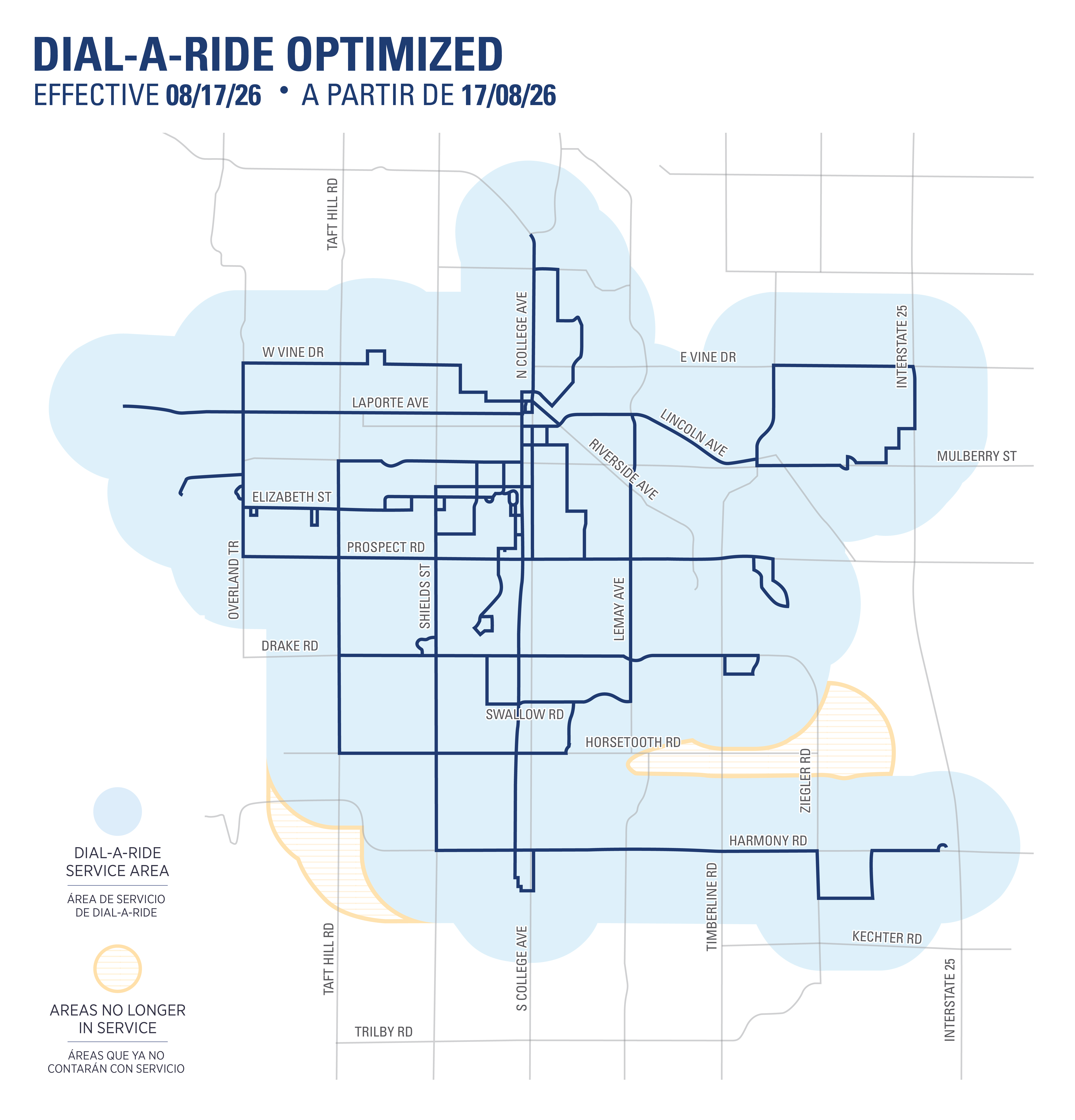
    Effective Aug. 17, 2026:


    This map shows expected Dial-a-Ride service changes taking place Aug. 17, 2026.


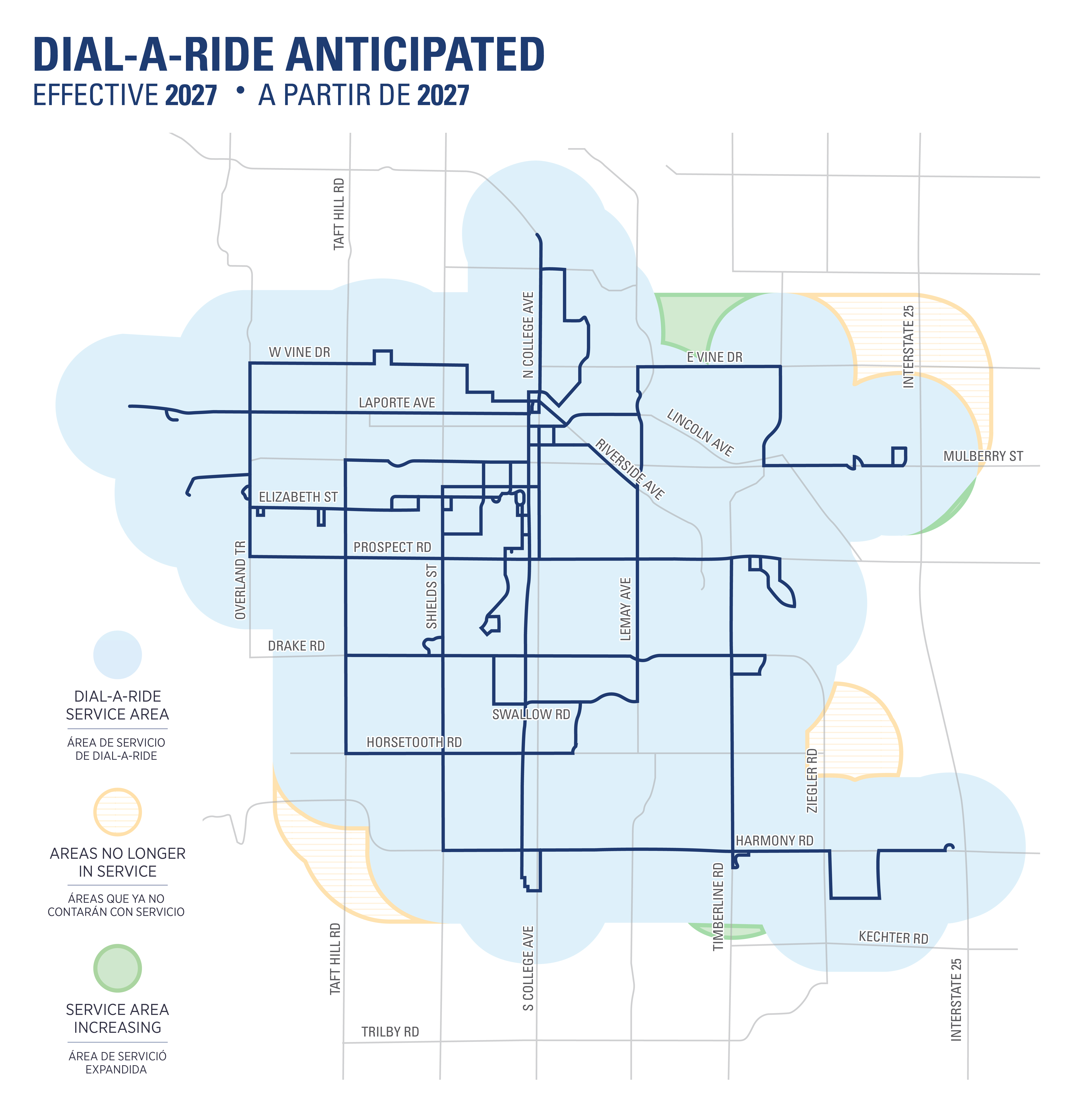
    Anticipated in 2027:

    This map shows expected changes to Dial-a-Ride coming in 2027.


    These maps reflect current plans and may undergo minor adjustments.

  • April 2026: Project Updates

    Share April 2026: Project Updates on Facebook Share April 2026: Project Updates on X (formerly Twitter) Share April 2026: Project Updates on Linkedin Email April 2026: Project Updates link

    Transfort presented the completed Optimization Study and Plan to City Council at the March 24 Work Session.


    Developed through extensive public engagement, data analysis, and industry best practices, the plan emphasizes frequency, reliability, simplicity and equitable access. The recommended scenario introduces a streamlined, grid-based network that strengthens high-demand corridors, improves connections to key destinations and operates within available resources.


    Transfort Optimization Map Key (for routes):Transfort Optimization Map Key. For assistance with this image, contact the City’s ADA Coordinator via email adacoordinator@fortcollins.gov or phone: 970-416-4254.


    The final plan supports ridership growth through a more efficient and intuitive system while remaining grounded in financial realities. Adjustments to Dial-A-Ride services are detailed in a separate April Project Update.


    Updated route maps

    Transfort presented the completed Optimization Study and Plan to City Council at the March 24 Work Session.


    Developed through extensive public engagement, data analysis, and industry best practices, the plan emphasizes frequency, reliability, simplicity and equitable access. The recommended scenario introduces a streamlined, grid-based network that strengthens high-demand corridors, improves connections to key destinations and operates within available resources.


    Transfort Optimization Map Key (for routes):Transfort Optimization Map Key. For assistance with this image, contact the City’s ADA Coordinator via email adacoordinator@fortcollins.gov or phone: 970-416-4254.


    The final plan supports ridership growth through a more efficient and intuitive system while remaining grounded in financial realities. Adjustments to Dial-A-Ride services are detailed in a separate April Project Update.



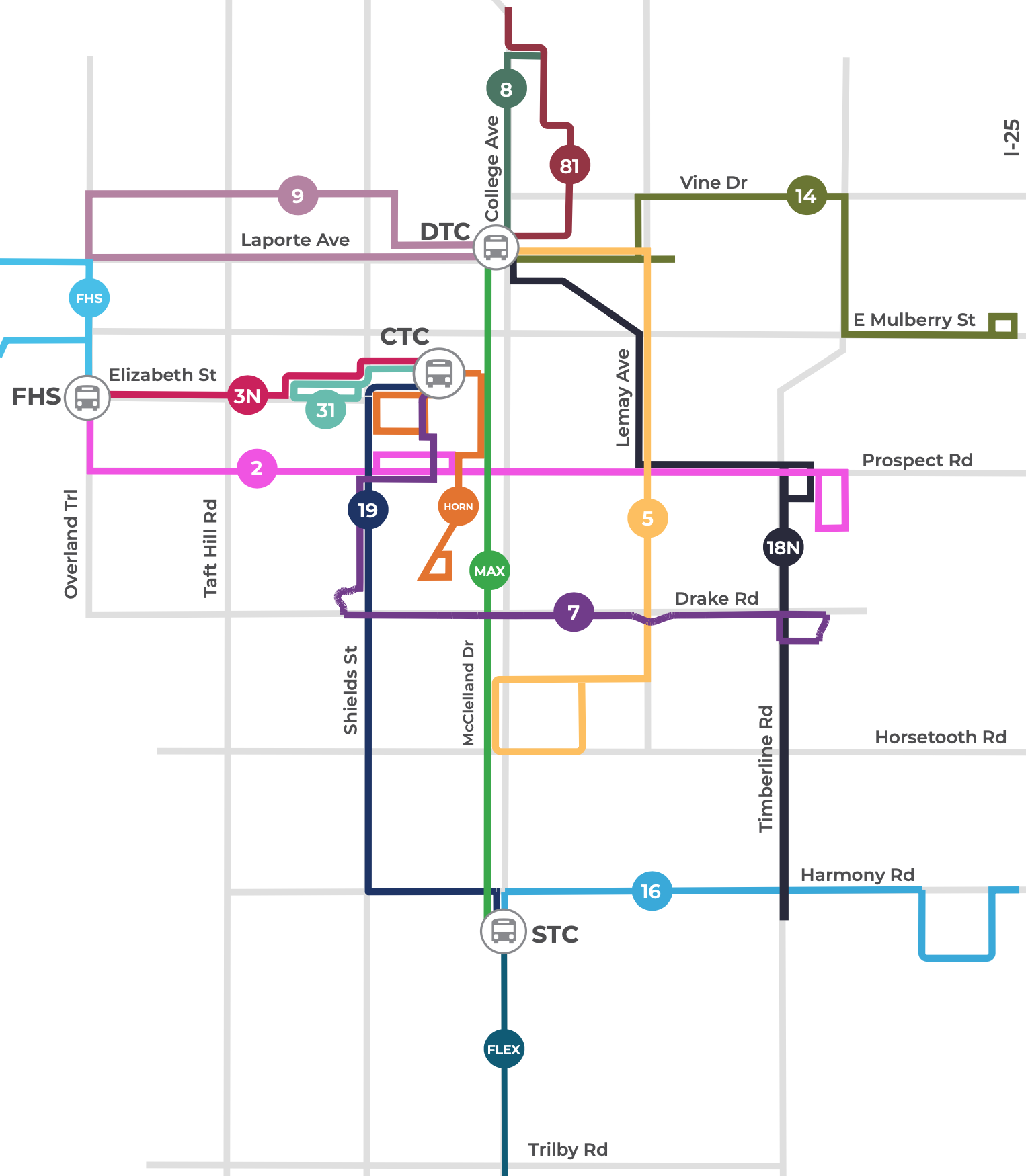
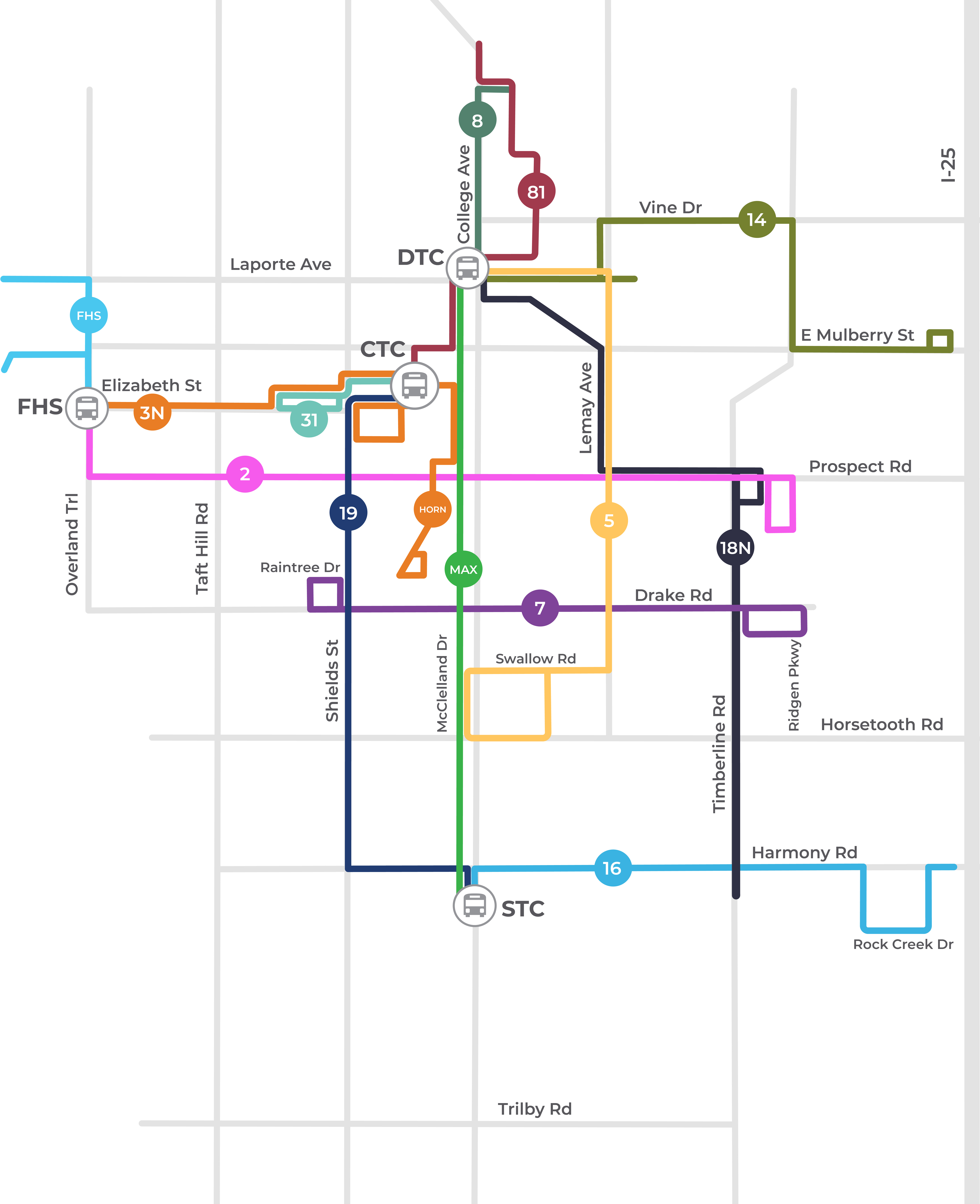
    Updated route maps are provided below. Most route service changes are scheduled for implementation in August 2026 while some routes which require significant realignment or new bus stops which are anticipated to change in 2027. These maps reflect current plans and may undergo minor adjustments.


    Map of the Tranfort network optimized routes effective Aug 17, 2026. For assistance with this image, please contact the City’s ADA Coordinator via email adacoordinator@fortcollins.gov or phone: 970-416-4254.


    Map of the Transfort network showing optimized anticipate routes 14 and 18, anticipated for 2027. For assistance with this image, please contact the City’s ADA Coordinator via email adacoordinator@fortcollins.gov or phone: 970-416-4254.


  • March 2026: Project Updates

    Share March 2026: Project Updates on Facebook Share March 2026: Project Updates on X (formerly Twitter) Share March 2026: Project Updates on Linkedin Email March 2026: Project Updates link

    Transfort provided a staff report to City Council in Council's March 24, 2026 Work Session and received support to move forward with implementation of the Transfort Optimization Plan beginning in August 2026.

    View a summary of the Council Agenda Item, the presentation to Council or watch the full Council Work Session.


    Transfort Service Changes to Expect

    Implementation will start to take place in August 2026

    Transfort provided a staff report to City Council in Council's March 24, 2026 Work Session and received support to move forward with implementation of the Transfort Optimization Plan beginning in August 2026.

    View a summary of the Council Agenda Item, the presentation to Council or watch the full Council Work Session.


    Transfort Service Changes to Expect

    Implementation will start to take place in August 2026 while some routes which require significant realignment or new bus stops could take longer. Updates will be provided if this timeline changes.

    Service Eliminations

    • Routes 10, 11, 12: Currently suspended, will be removed from Transfort service
    • Sunday service will not be provided for Fixed Route and Dial-A-Ride
    • Bus-Stop-to-Bus-Stop on-demand taxi service will be removed

    Service Enhancements

    • Route Realignments: 2, 3/32, 8, 14, 16, 18, 81
    • New Service: Timberline, East Prospect, CSU Campus connections, East Mulberry
    • Frequency Improvements:
      • MAX will operate at 15-minute frequencies all day
      • Routes 5, 9, and 14 will operate every 30 minutes during peak hours and every 60 minutes during off-peak hours
      • Route 8 will operate every 20 minutes

    A final map will be available in April.

  • February 2026: Project Updates

    Share February 2026: Project Updates on Facebook Share February 2026: Project Updates on X (formerly Twitter) Share February 2026: Project Updates on Linkedin Email February 2026: Project Updates link

    Transfort continues to work on a recommended transit scenario to bring to City Council in late March.

    After receiving feedback from residents near and around Laporte Ave., Transfort plans to maintain Route 9. A new map is available below.

    Feedback will continue to be collected through March 10. In late March, Transfort will present the recommended transit scenario to City Council and a final map will be available in April.

    Implementation will start to take place in August 2026 while some routes which require significant realignment or new bus stops could take longer. Updates will be provided if this timeline

    Transfort continues to work on a recommended transit scenario to bring to City Council in late March.

    After receiving feedback from residents near and around Laporte Ave., Transfort plans to maintain Route 9. A new map is available below.

    Feedback will continue to be collected through March 10. In late March, Transfort will present the recommended transit scenario to City Council and a final map will be available in April.

    Implementation will start to take place in August 2026 while some routes which require significant realignment or new bus stops could take longer. Updates will be provided if this timeline changes.

    Key notes about the routes shown on the map:

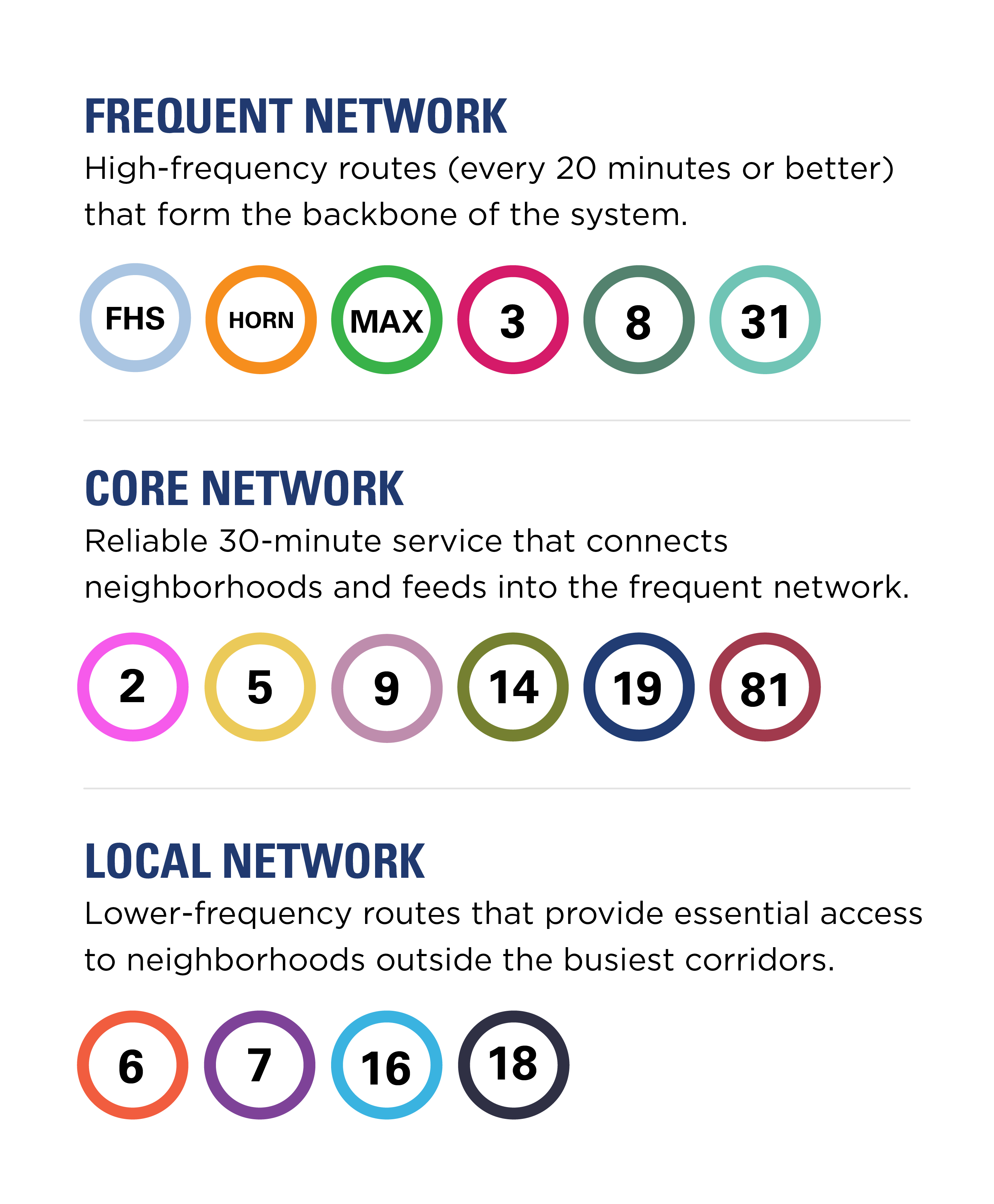
    • Frequent Network: High-frequency routes (every 20 minutes or less) that form the backbone of the system: MAX, 3N, 31, 8, HORN
    • Core Network: Reliable service (every 30 minutes) that connects neighborhoods and feeds into the Frequent Network: 81, 19, 5, 2, 14
    • Local Network: Lower-frequency routes that provide essential access to neighborhoods outside the busiest corridors: 7, 18N, 16, 9

    This is a map of Transfort's final recommended transit scenario, showing modified routes city-wide.


  • January 2026 Project Updates

    Share January 2026 Project Updates on Facebook Share January 2026 Project Updates on X (formerly Twitter) Share January 2026 Project Updates on Linkedin Email January 2026 Project Updates link

    As we head into the new year, here are a few updates from the Transfort Optimization Plan project team:

    After months of review and community engagement on the three proposed scenarios, combined with data analysis and transit industry best practices, a recommended transit system was developed. The recommended transit system was presented to City Council in October and received support. View the presentation under the Documents section on this page.

    As a next step

    As we head into the new year, here are a few updates from the Transfort Optimization Plan project team:

    After months of review and community engagement on the three proposed scenarios, combined with data analysis and transit industry best practices, a recommended transit system was developed. The recommended transit system was presented to City Council in October and received support. View the presentation under the Documents section on this page.

    As a next step in the process, two upcoming events will focus on sharing the recommended scenario – giving you an opportunity to ask questions and share your thoughts:

    Transportation Projects Fair

    • Date: Friday, Feb. 6
    • Time: 6-9 p.m.
    • Location: Center for Creativity, 200 Mathews St.

    Open House

    • Date: Monday, Feb. 9
    • Time: 10 a.m.-1 p.m.
    • Location: Downtown Transit Center, 250 N. Mason

    We hope you can join us for one of these events!

  • Recommended Transit Scenario

    Share Recommended Transit Scenario on Facebook Share Recommended Transit Scenario on X (formerly Twitter) Share Recommended Transit Scenario on Linkedin Email Recommended Transit Scenario link

    Based on community feedback, the recommended transit scenario creates a simple, grid-like route system that focuses service where it works best. It prioritizes neighborhoods with the greatest reliance on transit and connects people to key destinations, including schools, healthcare, shopping, human services and affordable housing.

    At the same time, the plan stays within financial limits by redesigning low-performing routes, using existing resources more efficiently and ensuring the system is practical to operate.
    Based on community feedback, the recommended transit scenario creates a simple, grid-like route system that focuses service where it works best. It prioritizes neighborhoods with the greatest reliance on transit and connects people to key destinations, including schools, healthcare, shopping, human services and affordable housing.

    At the same time, the plan stays within financial limits by redesigning low-performing routes, using existing resources more efficiently and ensuring the system is practical to operate.

  • Scenarios and Surveys

    Share Scenarios and Surveys on Facebook Share Scenarios and Surveys on X (formerly Twitter) Share Scenarios and Surveys on Linkedin Email Scenarios and Surveys link

    The three scenarios below are built around different philosophies and are meant to show trade-offs associated with limited financial resources. This project's final recommendation will not be exactly one of these three scenarios but rather a blended hybrid based on analysis and community input.

    Routes not shown that will continue to operate as they do now: HORN, FLEX*, GOLD, Foothills Shuttle.

    *FLEX may include extensions, altered hours or other modifications.

    Surveys

    Surveys were completed July 14, 2025. We'll publish survey findings here soon.

    For more information about how each scenario was developed, see the presentation in the Documents

    The three scenarios below are built around different philosophies and are meant to show trade-offs associated with limited financial resources. This project's final recommendation will not be exactly one of these three scenarios but rather a blended hybrid based on analysis and community input.

    Routes not shown that will continue to operate as they do now: HORN, FLEX*, GOLD, Foothills Shuttle.

    *FLEX may include extensions, altered hours or other modifications.

    Surveys

    Surveys were completed July 14, 2025. We'll publish survey findings here soon.

    For more information about how each scenario was developed, see the presentation in the Documents section of this webpage.

    Scenario 1: Travel Patterns

    Scenario 1 prioritizes high frequency, direct bus routes on corridors where people already travel the most.

    Scenario 2: Rider Demand

    Scenario 2 prioritizes direct connections for areas with the highest current or anticipated transit demand.

    What is microtransit? Microtransit is a flexible, on-demand transportation service that operates as a shared ride system (similar to Uber or Lyft), typically using smaller vehicles.

    Scenario 3: Condensed Network

    Scenario 3 provides a condensed bus network for the highest demand areas and microtransit for lower density areas.


    In addition to the online survey and community events, we are engaging with the following community groups and organizations for their feedback: Chamber of Commerce, City Boards and Commissions, Community Connectors, Downtown Development Authority, Housing Catalyst, Larimer County Assistance Coalition, Larimer County Mobility Committee, Midtown Business Improvement District, North Fort Collins Business Association and Poudre School District.


  • Welcome to the page!

    Share Welcome to the page! on Facebook Share Welcome to the page! on X (formerly Twitter) Share Welcome to the page! on Linkedin Email Welcome to the page! link

    Hi everyone - welcome to the Transfort Optimization Plan webpage! We'll be posting content and opportunities to engage with us on this project in the coming months. If you'd like to follow along, tap or click the Subscribe button near the top of the page to stay up to date with this project. Thanks for your interest and participation.

    Hi everyone - welcome to the Transfort Optimization Plan webpage! We'll be posting content and opportunities to engage with us on this project in the coming months. If you'd like to follow along, tap or click the Subscribe button near the top of the page to stay up to date with this project. Thanks for your interest and participation.

Page last updated: 24 Sep 2026, 04:13 PM