Montava Development Proposal
How to get involved:
- Follow this project on OurCity
- Learn about details of this project below
- Reach out to the staff listed on this page or leave a question below
- Submit a written comment below or emailed to devreviewcomments@fortcollins.gov
- If you live near the project, keep an eye for letters from the City about upcoming events related to this project
About the project
Overview
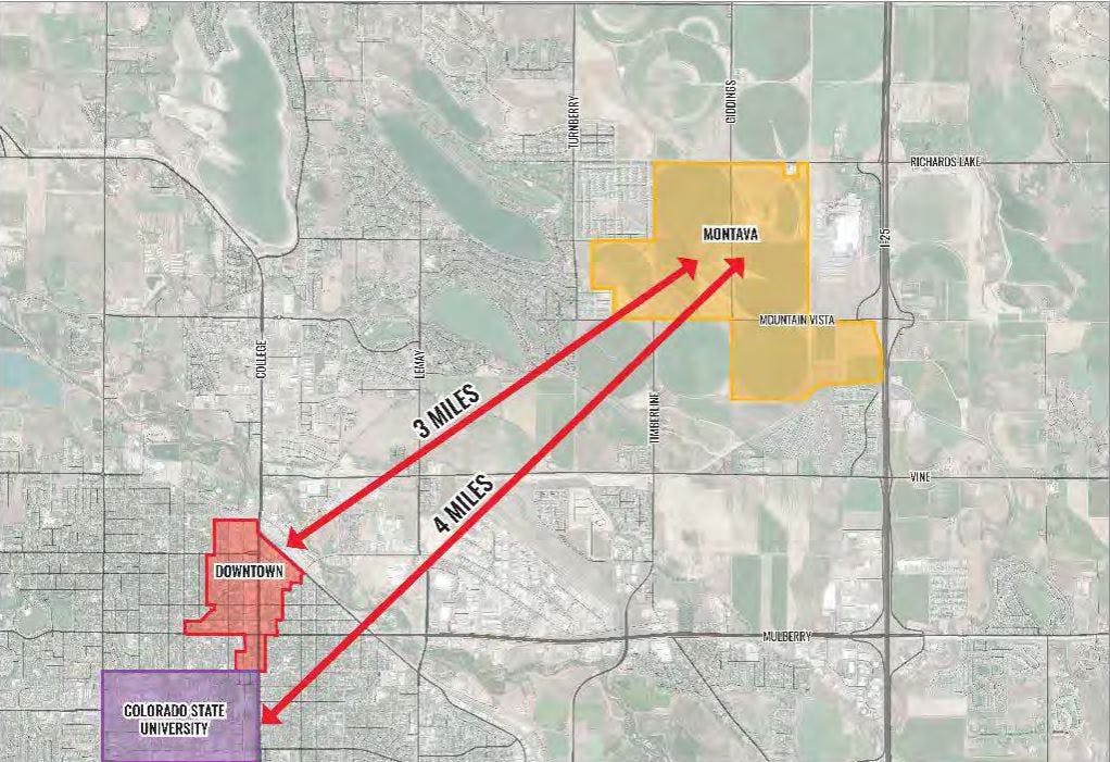
Montava is a proposed development for a section of rural and agricultural land next to the Anheuser-Busch facility in northeast Fort Collins. The 860-acre proposal is modeled off of Traditional Neighborhood Development (TDN) or village-style development because of the wide variety of land uses. The development would include a variety of housing, amenities and public spaces. The proposal calls for a complete, connected community with new neighborhoods, parks, schools, a town center, urban agriculture, businesses, and transportation connections. The project is expected to take 10-20 years to complete.

Public Benefits
The Montava development will provide public benefits such as:
Comprehensive, large-scale master planning of the Montava community,
A community design based on “New Urbanist” principles, which promote walkability, mixed-use spaces and a strong sense of place,
An agri-urban model that includes a working farm and high-quality gardening opportunities throughout the neighborhood,
Construction of Zero Energy Ready Homes that meet high energy efficiency standards,
A non-potable water system to irrigate all public and private landscaping, reducing demand on drinking water supplies,
The inclusion of affordable and workforce housing to support a diverse range of incomes.
Traffic
The City of Fort Collins Master Street Plan illustrates how the Montava development will be supported by a network of major roads. Two- and four-lane arterial roads will serve the site along Richards Lake Road to the north, Mountain Vista Drive to the south, and Timberline Road to the west. Additional access will be provided by Turnberry Road, located farther west of the development. Within the community, Giddings Road will serve as a central route. On the eastern side, the I-25 Frontage Road will function as a two-lane collector road, providing further connectivity.
As part of the approval for the Montava Planned Unit Development (PUD) in 2020, a Master Traffic Impact Study was completed. This study helps the City and the applicant understand the anticipated traffic impacts of the project and identify the improvements that will be needed to the citywide transportation network to support the development.
The study evaluates current street and traffic conditions, including vehicle, transit, bicycle and pedestrian activity today. It then uses City and regional data to predict what traffic volumes would likely be in the year 2040 without the Montava development, if Montava were never built. Next, it adds these baseline traffic predictions to the projected traffic from Montava to estimate total traffic levels in 2040. Traffic engineers use these projections to identify improvements that will need to be made to the city’s road network in order to account for Montava’s specific traffic impacts. All development projects in Fort Collins create studies like these, so Montava is not the only development that will be improving the city’s road network over time.
The Master Traffic Impact Study recommended that Montava make four categories of improvements to our transportation network. These categories are 1) intersection improvements, 2) road improvements, 3) contribution to our regional trail network and 4) infrastructure for transit.
Here are the intersection improvements that Montava will be required to provide, based on the Master Traffic Impact Study recommendations. In addition to the improvements required of Montava, the City, County and other development projects in the area are also making improvements to the transportation network.

Bicycle and Pedestrian Network
The Montava development also includes plans for an accessible bicycle and pedestrian travel network. Montava will contribute to paying for and constructing the regional trail network in areas in and around the development project. Because of this project, the City plans to add a new bus route to serve the area.


Water
The entire Montava development is planned to receive water service from the East Larimer County (ELCO) Water District. ELCO has issued a “will-serve” letter confirming its commitment and capacity to provide water to the full development. The Montava team will be responsible for installing all water lines in accordance with ELCO’s standards and requirements. In addition, Montava will contribute raw water rights and pay the necessary fees to join the ELCO system.
Stormwater
Northeast Fort Collins has stormwater management challenges for new development because it is located within the Upper Cooper Slough Basin, an area with limited existing drainage infrastructure and a history of flooding. The Montava development will be required to design and build stormwater detention and drainage systems that meet the City of Fort Collins’ standards. These systems must prevent flooding both within the development and in areas downstream. They must also include measures to treat stormwater and remove pollutants before the water is released into natural systems such as ditches or rivers. These types of requirements apply to all new developments and redevelopments built in Fort Collins.
Project Phases:
In Review - Phase G: Southwest Neighborhood (BDR210013): This phase was submitted to the City of Fort Collins in December of 2021. This phase proposes 200 housing units, including townhomes, duplexes and small- and medium-sized detached houses. This phase will build a pedestrian underpass under Mountain Vista Drive and add to the regional trail network.

In Review - Phase E: Town Center Residential (BDR220003): This phase was submitted to the City of Fort Collins in August of 2022. This phase proposes 246 housing units, including townhomes, detached houses, multi-unit apartments and mixed-use buildings. Phase E will also include the future City-owned park.

Phase D: Core, Irrigation Pond and Infrastructure (BDR240006): This phase was submitted to the City of Fort Collins in in October of 2021. This application was split into two parts: the Core and Irrigation Pond (D(a)) and the Infrastructure (D(b))
- Approved - Phase D(a) - proposes around 460 homes, including single-unit attached and detached homes that will be alley-loaded and a tract with multi-unit apartment buildings. This phase also proposes to build the irrigation pond that will feed the non-potable irrigation system for the entire development, including the school sites and the City-owned park.
- Approved - Phase D(b) - proposes to build major roads and associated public works, including streetlights, water and wastewater systems and street-side landscaping that will be necessary within the Phase D Core and Irrigation Pond project application. It will build a roundabout at the intersection of Timberline Road and Maple Hill Drive. It will build a “fiddle”-shaped roundabout at the intersection of Giddings Rd., Maple Hill Dr., and Montava Ave.

Project Timeline
| Date | Milestone | Records |
| October 11, 2018 | Neighborhood Meeting | Summary |
| December 19, 2018 | Neighborhood Meeting | Summary |
| December, 2021 | Phase G Submitted | Submittal |
| August, 2022 | Phase E Submitted | Submittal |
| November 2, 2022 | Neighborhood Meeting | Recording |
| August, 2023 | Minor Amendment Submitted | Submittal |
| Phase D Approved | Submittal |
Who's listening
-

Phone 9702246076 Email emyler@fortcollins.gov -
City Planner
JBEmail jbaty@fortcollins.gov